Multimedia Ģ Reference Ģ Religion Ģ Travel |
 The Holy Land Satellite Map
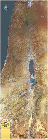
Description From The Publisher: The colour data in this image was derived from the U.S. LANDSAT 5 satellite, which passed over the area at a height of 580 miles (930 km). The detail in this image was enhanced by the addition of black and white data from the French SPOT IMAGE satellite. The final result is a true-color high-resolution image measuring 19 inches (48 centimetres) across and 55 inches (140 centimetres) down. There are over 40 different geographical markings including such major cities as Tel Aviv, Amman, and Jerusalem as well as various geographical and historical points of interest including Qumran, Madaba, Sepphoris, and Mt. Hermon. Printed on heavy glossy stock with two protective metal strips at the top and bottom for convenient wall hanging. Shipped rolled in a tube. Look for Similar Items by Subject | |||
Copyright ©1996-2023 CenturyOne Bookstore. All Rights Reserved. All prices subject to change and given in U.S. dollars. Your purchase from CenturyOne.com will assist the CenturyOne Foundation in providing funding for various archaeological and research projects which seek to provide more information about the period of the First Century C.E., the origins of Christianity and the world of the Bible in general. All materials contained in http://www.centuryone.com are protected by copyright and trademark laws and may not be used for any purpose whatsoever other than private, non-commercial viewing purposes. Derivative works and other unauthorized copying or use of stills, video footage, text or graphics is expressly prohibited. |